SnoFax
Travel • Sports • Preparedness
2/7/2025 SnoFax Update Early 1-3" OVERNIGHT @ 5AM , S WINDS PREVAIL
February 07, 2025
post photo preview

1-3" NEW SNOW OVERNIGHT @ 5AM, SOUTH WINDS CONTINUE TO HOWL, STORM SKIING TODAY

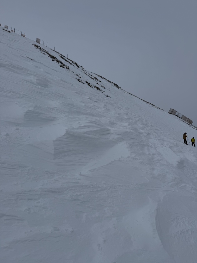
1-3" of new snow has blown in overnight as of 5am, and I'm up now so I figured today's report could come a little earlier. The wind is the major factor, as it continues to wreak havoc on our upper mountain terrain. Huge thanks to Taylor for these great photos and SnoFax reporting. Skiing off of the Tram is not for the faint hearted right now, you will be faced with wind slabs and sheets of ice. Liberty Bowl being the most damaged. Things are likely the same if not worse up there today, as South winds have continued gusting to 50mph overnight. Down low and out of the wind, skiing looks great in the Bowl, and Chalky off of Challenger. Not sure if Swifty will continue running at reduced speed today, would definitely appreciate any updates that anyone can provide on that.

WIND AND TEMPS: Today is going to be a cold and snowy day out there, with temps ranging between 1°F at the summit, and 16°F at the base, and winds are expected to continue out of the South for most of the day, hopefully only gusting to around 35mph at the summit by the time we open. Significant snowfall expected between now and 9am, so keep an eye on the weather stations this morning if you'd like to see how fast it is stacking up, my guess is we could see a few more inches before noon. 

4232732_5b1hndojx91ovwj_custom.jpeg

There's plenty of great skiing to be had, and there's always hope that the South Face will heal up despite all of this wind damage. Just one shift in the weather and things can change overnight. It's going to be cold out there which should help keep the crowds down, but if Swifty isn't at full speed there's no avoiding a bit of a wait at the base and Ram Charger could get backed up as well, with a Super G race taking place on Hangmans. If you dress warm and ready to chase down the good skiing from lift to lift, today could involve a lot of vert and a lot of pow if it keeps dropping this morning. Keep up the great work SnoFax community! Let's help make sure everybody knows what they're getting into out on the mountain! 


As always, remember to stay safe, and have fun out there.


community logo
Join the SnoFax Community
To read more articles like this, sign up and join my community today
4
What else you may like…
Videos
Podcasts
Posts
Articles
Ice rink roads Big Sky

Slicker than snot, dead stop at town center

00:00:08
MORE SNOW FALLING IN BIG SKY 11/05/2024

A couple of inches already this morning and it's not stopping any time soon!

MORE SNOW FALLING IN BIG SKY 11/05/2024
SNOW on The Mountains!

6" recorded at ANDESITE, LIKELY EVEN DEEPER HIGHER UP! WINTER IS COMING SOON!

SNOW on The Mountains!
SnoFax. A snow report by the people, for the people.

Share this with your friends and let's create a new future of snow reports for Big Sky.

SnoFax. A snow report by the people, for the people.
4/24/2025 SnoFax

High Flying clouds, temps topping off at 40°F, we're in for another great day of fast, edge-able groomer skiing on the lower mountain. Doubtful that the South Face has healed up from the crust... Days like these fly by just like the winter season. Keep your skis on edge and you'll fly down the mountain easily. level them out and things might get a little grabby.

post photo preview
4/22/2025 SnoFax

Sunny Spring Skiing or cloudy with snow? Hard to say. Temps well below freezing for the last 24 hours, but that sun is out and shining right now. Expected to climb to about 40°F, things could soften up, but right around noon when that would happen, more clouds and snow could roll through. Chance for snow like this the next few days, sun Saturday, and maybe rain on closing day... But I doubt that... The weather cannot make up it's mind right now! Great day for groomers, maybe things off the Tram have gotten a little wind buff.

4/21/2025 SnoFax

Another inch over night so some more Dusty Crusty out there today! Hopefully winter stikes back full throttle with more snow today and tonight! Pretty sure North Side is closed and limited lifts for this last week. Get out and savor it while you can!

4/14/2025 SnoFax Update FREEZING TEMPS PREVAIL, FOR NOW...

TRACE OF NEW SNOW IN 48 HRS

Temps are still down, but the bluebird is out and sure to warm things up fast down low today. Up high, NW winds prevail gusting to 30mph, keeping temps well below freezing, and wind grooming the epic North Side spring skiing we have been seeing all month. Be ready to shed some layers if you get out there this morning as temps are expected to climb to the mid 40's. Another beautiful day on the mountain practically all to yourself!

Read full Article
post photo preview
4/10/2025 SnoFax Update MELTDOWN

NO NEW SNOW FOR 24 HRS

No new snow to talk about and things are expected to get HOT out there today. Typical spring skiing stuff which is why SnoFax has been slacking. Westerly winds topping 60mph provided awesome wind buffed skiing on the North Summit Yesterday, and down low, things took a while to soften up but soften up they did. 

WIND AND TEMPS: Westerly winds are expected to shift more Southerly, bringing temps to 30°F at the summit, and 55°F at the base, by the time we close. Clouds are expected to be rolling through all day long, hopefully keeping the sun from nuking our base. Winds are expected to die down, only gusting to 30mph at the summit. 

Another beautiful day with plenty of base to work with! Watchout for long catwalks once again as when temps get well over 40°F, things can get sticky. 


As always, remember to stay safe, and have fun out there.

Read full Article
post photo preview
4/6/2025 SnoFax Update SUPER SPRING SKIING

NO NEW SNOW

There's been no new snow for a couple of days now, and temps are going to be very springy out there today. Yesterday things didn't warm up too much, but it is going to be an icy morning out there for sure, as temps have dropped into the mid 20's. Today, strong sun, warm air and little wind are going to add up to warm conditions that will likely become sticky. The ideal window is something like 10:30-1:30 out there if you ask me. The Bowl, and North Facing upper mountain slopes should still provide soft wintery snow and chalky turns.

WIND AND TEMPS: Today's temps are expected to range beteween 25°F at the summit, and 45°F at the base, with mid mountain temps climbing to 40°F. And calm Westerly winds at lower elevations will gust to a max of 30mph at the summit, all under bluebird skies. 

Over the last 24 hours, NW winds have been steady at the summit, hopefully keeping our snow cold and recycled up there to prevent a thaw then a freeze, today, temps may get too warm to have that same hope, but you never know. Lots of warm weather this week as it seems the meltdown is beginning. Keep praying for snow!


As always, remember to stay safe, and have fun out there.

Read full Article
See More
Available on mobile and TV devices
google store google store app store app store
google store google store app tv store app tv store amazon store amazon store roku store roku store
Powered by Locals